Nadia Amoroso, Director of Nadia Amoroso Studio and adjunct Professor in Practice, at University of Guelph shares with us her insights on ArcGIS Online and GeoPlanner for ArcGIS Online for Urban Design and Planning. In the past decade, planning and design professions have been enriched by a wealth of readily available site data. GIS (Global Information Systems) programs and applications provide layers of information on everything from site hydrology to population density, but urban designers, planners and landscape architects may shy away from utilizing GIS data, perceiving the applications as being too complex. GIS tasks are often passed onto a tech specialist, causing a slowdown in workflow, a lack of integration between departments and a less than perfect understanding of the data by the design team. In recent years, ESRI, a global leader in the mapping and GIS sector, has provided easy to use, design focused GIS applications that can be used by everyone working in a planning or landscape architecture company. One of these intuitive mapping and GIS applications offered by ESRI is ArcGIS Online.
ArcGIS Online
ArcGIS Online is a web-based GIS and mapping application, extending the reach of GIS to anyone in an organization. Designers and planners of all levels can easily create maps or site inventory and analysis diagrams, and then share them with anyone in the firm. Since the application is web-based, map-drawings can be viewed on mobile devices, making them easy to access in meetings or on job sites. A Software Solution ArcGIS Online can be considered as part of the Esri’s software solutions in support of the Geodesign framework. Geodesign is a term that refers to utilizing nature’s or the site’s data as part of the design process, along with the integration of GIS software to gather, evaluate, create, design, visualize and assess designs using this evidence-base support.
Gallery of date. Image courtesy of Nadia Amoroso
Browsing through Esri’s Gallery of Data To create a drawing, the designer can browse through Esri’s extensive Gallery of data or open data sources, and then import that data into ArcGIS Online to begin the project. Once imported, the graphic representational style of the map can simply be changed to generate specific drawing types. The designer can even change the base map “look” to customize the presentation of the map-drawing.
Base map change. Image courtesy of Nadia Amoroso
The example below is a figure-ground map created in ArcGIS Online. The figure-ground is a type of drawing used in urban planning and design to visually convey the urban fabric. Typically all built form (buildings) is represented by black, and open space (including streets and waterways) is either represented by white or left void. In the following drawing, larger areas have been shaded to graphically convey the street network/urban block configuration. This map-drawing was created by importing Manhattan parcel data; information found on ESRI’s Gallery page. With black color applied to the parcel data layer, the figure-ground drawing was instantly created. The color, overall graphic style and transparency levels were all intuitively discovered, the interface being easily understandable by a first time user.
Image courtesy of Nadia Amoroso
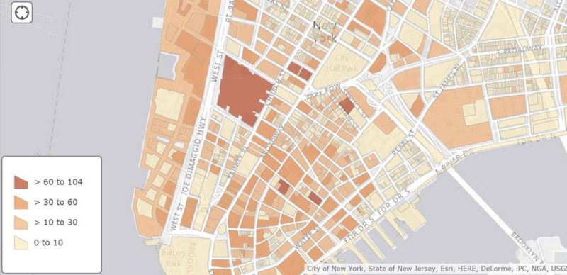
Assisting Informed Urban Design The power of the drawing lies in the data contained within the parcel shapes. The attributes include number of floors, floor/area ratio, square footage, building usage, property value, lot size, and much more. This attribute data gives the designer instant information, facilitating informed urban design and planning decisions. The second image utilizes the same parcel data in a different way. In this instance, the map-drawing conveys the number of floors in a building based on intensity of color (shown here through the orange-yellow range), but maps and legends can be customized by color and classification to show a wealth of diverse information. The possibilities for displaying information are limited only by the imagination of the designer.
Image courtesy of Nadia Amoroso
Making it an integral Part of the Process ArcGIS Online can be easily integrated into the design workflow at any stage. For example, the urban designer can search and gather initial site data and visualize his/ her primary or secondary geo-data via ArcGIS Online. The designer can visualize and map conditions, systems and elements such as mobility networks, walkability, density, soils, and any other general site and urban information as part of the site inventory stage. Designers can then perform various site analyses with ArcGIS Online such as view sheds, buffer zones and hot spots. ArcGIS Online offers the non-GIS user, including architects, landscape architects and urban designers the opportunity to use GIS applications throughout the initial stages of a design, enabling the presentation of well researched digital map-drawings.
Analysis tab. Image courtesy of Nadia Amoroso.
GeoPlanner GeoPlanner is another of Esri’s web-based applications, and part of Esri’s software solutions in support of the Geodesign framework, offering specific features geared for complete land-based planning and design projects. GeoPlanner for ArcGIS facilitates smooth workflows in support of environmental design. City planners and designers create, sketch, design, evaluate, and compare scenarios using customizable dashboards. Bring Confidence to Design They can create various schemes and apply customized indictors to assess outcomes and come up with optimum design solutions. Because GeoPlanner is underpinned with GIS data, the designer is able to provide an objective basis for the design. The data, combined with powerful analysis, leads to solid decision-making, resulting in a design that can be shared confidently with all the stakeholders on a project. Creating Evidence-Based Designs GeoPlanner, like ArcGIS Online, is quite intuitive, extending GIS and Geodesign capabilities to everyone, and both applications are great tools to help the non-GIS user, designer and planner utilize the power of GIS in their work. Now everyone in a design and planning organization can integrate GIS data into the design workflow, share information with one another, and produce evidence-based designs. WATCH: How to Create Figure Ground Drawings, Quickly and Easily
If this is your first time on the new site, please click "Forgot your password?". Follow the steps to reset your password. It may be the same as your old one.